1. Aerodrome Identification
2. Aerodrome Operator & Contact
3. Communications
Radio Requirements
Carriage and use of VHF radio is MANDATORY. Jaspers Brush lies within Nowra military controlled airspace. Monday to Friday, contact Nowra TWR on 118.85 and obtain a clearance before entering. Outside those hours — most weekends and when the tower is closed — 118.85 operates as CTAF: broadcast all inbound, outbound and overflying intentions. Confirm ATS status on the YSNW ATIS before departure; ATS may be activated at short notice.
Frequencies sourced from Airservices Australia DAPS, Nowra (YSNW), editions 2025-SEP-04 and 2026-JUL-09, and the RAAF FIHA Nowra AD2 Supplement. Verify against current ERSA and NOTAMs prior to flight.
4. Airspace & Priority
- Jaspers Brush ALA lies within NOWRA MILITARY CONTROLLED AIRSPACE (R421A / R421B). R421A extends SFC to FL125 when activated by NOTAM.
- Monday to Friday the airfield operates under military control. A clearance from Nowra TWR on 118.85 is required. Review NOTAMs and confirm R421 activation prior to arrival.
- Outside military control hours — most weekends — 118.85 operates as CTAF. All operations self-announce.
- Drone / UAV operations, including drops from drones, are permitted only during tower-controlled periods with Nowra TWR monitoring. Outside those periods they are not permitted unless the drone operator maintains VHF communication with aircraft. All drone activity MUST cease for inbound aircraft.
- Active hang-gliding / para-gliding / cable tow / parachute activity possible in vicinity — see Sections 10 and 13.
- Military helicopter training OPS may be in progress — see Section 12.
5. Approved Aircraft Types
Jaspers Brush ALA supports a broad range of aircraft and aviation activities, subject to PPR.
| Category | Operations |
|---|---|
| Light fixed-wing aircraft | AVBL — subject to weight and strip condition. |
| Turbo-prop aircraft | AVBL — subject to weight and strip condition. |
| Ultralights (incl. RA-Aus) | AVBL — must comply with RA-Aus OPS requirements |
| Towed aircraft (gliders, banner tow) | AVBL — coordinate with AD OPR |
| Winch / cable launch aircraft | AVBL — see Section 10 Cable Tow Area |
| Drones / UAVs | AVBL — see Section 11 Drone Operations |
| Helicopters (civilian & military) | AVBL — see Section 12 Helicopter Training |
| Parachute operations | AVBL — see Section 13 Parachute Operations |
6. Runways & Landing Areas
6.1 Gravel Runways
| RWY | Length | Width | Surface | Remarks |
|---|---|---|---|---|
| 13/31 | 1000 M | 12 M | Gravel road base with sealed intersection | — |
| 05/23 | 850 M | 12 M | Gravel road base | — |
Windsock at intersection (unlit)
6.2 Grass Runways
| RWY | Length | Width | Remarks |
|---|---|---|---|
| 23 LEFT grass | 350 M | 20 M | — |
| 05 RIGHT grass | 350 M | 20 M | — |
| 13 LEFT grass | 600 M | 20 M | — |
| 31 RIGHT grass | 600 M | 20 M | After intersection |
6.3 Markings, Lighting & Surface
| Item | Details |
|---|---|
| Markings | NIL — no runway edge or threshold markings. |
| Windsock | Located at RWY intersection (S side). WINDSOCK IS NOT ILLUMINATED. |
| Lighting | NIL — no RWY lighting and no windsock illumination. Daylight OPS only unless PRIOR ARR with AD OPR for portable lighting. |
| RWY Strip Width | Gravel runways — 12 M. Grass runways — 20 M. |
Surface Condition Warnings
7. Schematic Layout
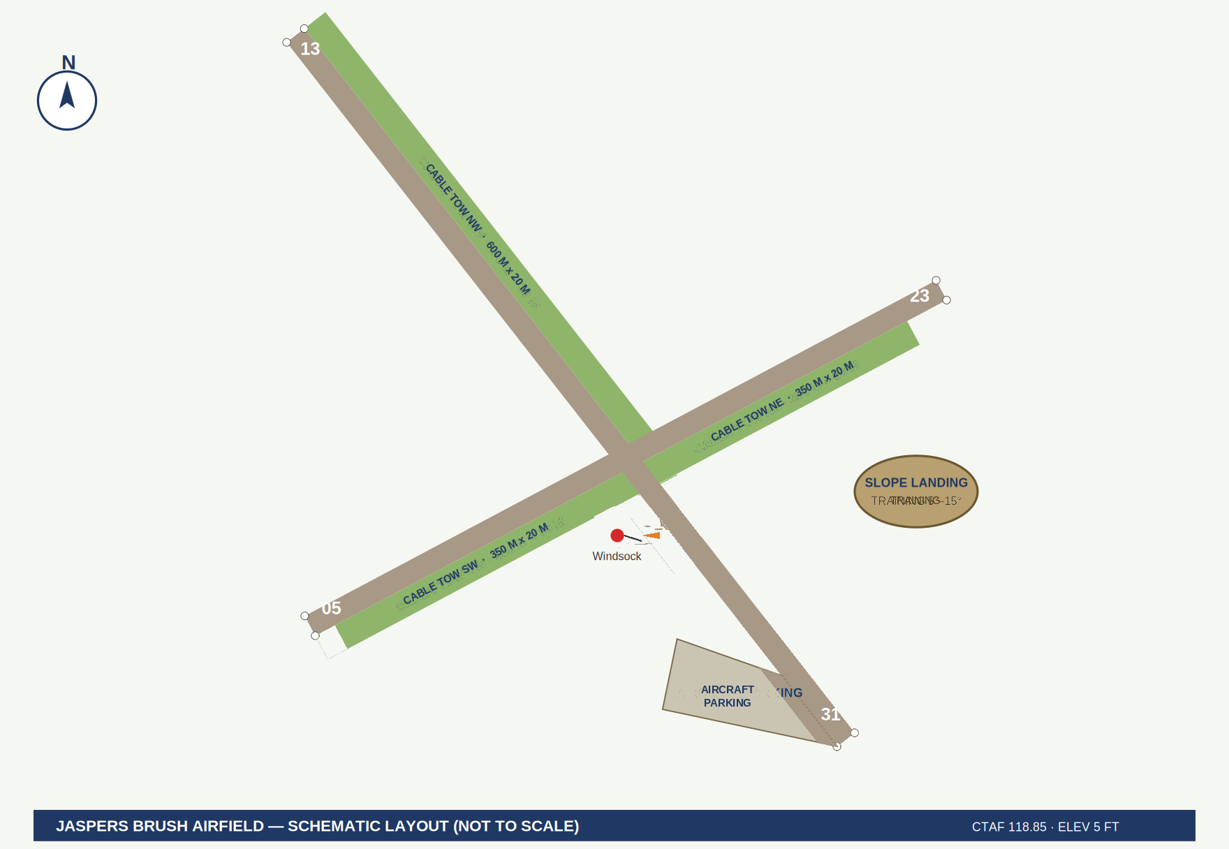
Figure 1 — Jaspers Brush ALA schematic layout (not to scale). Refer Sections 6.1 and 6.2 for published runway dimensions.
8. Parking
- Parking available NW of intersection.
- Gravel parking RHS of RWY 13, SW corner.
- Helicopter PRKG: SW of intersection on grass adjacent to windsock; also gravel parking RHS of RWY 13 SW corner.
- Own tie-downs required to secure ACFT — seasonally strong W and S winds.
- Chocks recommended. No fuel, no GPU, no maintenance services on site.
- Overnight parking — refer Section 18 Fees.
9. Noise Abatement / Fly Neighbour Friendly
- FLY NEIGHBOUR FRIENDLY — avoid overflight of populous areas on arrival and departure where operationally possible.
- LIMIT CIRCUITS — minimise CCTS count to reduce community noise impact. Consolidate training sorties where practical.
- LIMIT OVERFLYING NEIGHBOURS — avoid repeated overflight of adjoining properties and residences.
- Departure RWY 31: as soon as safe to do so, make early L turn and track for Shoalhaven Heads.
- Minimise low-level OPS over Berry township and nearby residential areas.
- LIMIT EARLY MORNING AND LATE EVENING FLIGHTS — training and circuit work should be scheduled between 0800 and 1800 local where operationally possible.
10. Cable Tow, Winch & Glider Ops
- Cable tow, winch and glider operations are conducted on the grass runways, clear of the gravel strips. Dimensions as per Section 6.2.
- Tow run alignment: approximately 130°/310° magnetic, 600 M usable tow run.
- Used for glider winch launching, paragliding tow, and sport aviation training.
- Cable tow activity ONLY conducted when fixed-wing OPS suspended, or by coordination with other users onsite — VHF ground and air required.
- Ground marshals in HI-VIS present during all cable tow activity.
11. Drone / UAV Operations
Jaspers Brush ALA offers dedicated drone and UAV operational services, including security-controlled testing and exclusive-hire arrangements.
| Service | Description |
|---|---|
| Tower Control Requirement | Drone / UAV operations are available ONLY during active tower control from Nowra TWR. Outside active tower control periods, drone and UAV operations are not available. Refer Section 4. |
| Test Flight Area | Dedicated UAV / drone test flight zone within ALA boundary. Suitable for commercial, experimental and R&D OPS. |
| Target Drops | Airfield supports drone-dropped targets and experimental payload release trials, including inert and dummy stores. |
| Experimental Devices | Testing of experimental UAV devices, sensors, and airborne equipment supported, subject to risk assessment. |
| Security Controlled Testing | Secure, access-restricted drone testing available for defence, government and commercial clients. NDAs accommodated. |
| Access Control | Gated access with security-controlled entry during sensitive OPS. |
Refer Section 4 for drone operating restrictions relative to tower-controlled periods.
12. Helicopter Training
Jaspers Brush ALA provides an extensive and purpose-configured helicopter training environment suitable for both military and civilian rotary-wing OPS.
12.1 Training Areas
| Training Area | Description |
|---|---|
| Confined Space | Confined space available. Numerous sites on property. |
| Slope Landings | Multiple slope landing areas located across the airfield — contact AD OPR for locations. Gradients from 5° through to maximum cyclic limits and beyond. Single-skid and front-skid-contact-only training available. |
| Dust Bowl | Prepared loose-surface dust bowl for Degraded Visual Environment (DVE) / loss of visual reference during landing (brownout) training. Highly experienced pilots only, with a suitably qualified instructor. This facility is primarily suited to military operations. |
| Grass Paddock Landings | Open paddock landing training on rural grass surface, variable length cut. |
| Gravel Area Landings | Compacted gravel training area — replicates forward operating base / austere surface OPS. |
| Bambi Bucket Pickup | Water pickup area suitable for Bambi Bucket / firefighting bucket collection training. |
| Bambi Bucket Drop Zone | Treed drop area for Bambi Bucket release practice — simulates forested firefighting environment. |
| Live Fire Training | During approved burn season, contained live fires can be arranged on site for firefighting rotary training and aerial firefighting practice. |
12.2 Operating Notes
- Military units may book the entire ALA (see Section 11).
- Gravel pads available for fuel trailers / tankers for firefighting equipment.
- Day VFR OPS standard. NVG / HN OPS by prior written arrangement, except military — no prior notification required.
13. Parachute Operations
Jaspers Brush ALA supports parachute operations including sport, tandem, experimental and military training jumps. All parachute OPS require PPR.
- DZ and landing areas vary depending on wind direction.
- Parachute OPS only conducted under PPR from AD OPR.
- Fixed-wing and rotary OPS suspended or segregated during active parachute OPS.
- Military parachute training accommodated.
- Ground observer / drop zone controller in HI-VIS present during all parachute OPS.
- Tandem, experimental and cargo drop OPS supported subject to risk assessment.
14. Obstructions / Hazards
| Obstruction | Location | Remarks |
|---|---|---|
| Tree hazard | N of RWY 13 approach | To a height of 10 M. Close proximity to approach path. |
| Rural fencing | Each RWY start and end | — |
| Elevated road | Each RWY start and end | 0.5 M high — caution on landing roll |
| Agricultural activity | Seasonal | Silage and primary production OPS may be active |
15. General Cautions
- Give way to military fixed-wing and rotary.
- Unsealed surface — refer to the surface warnings at Section 6.3.
- Possible drone / hang-gliding / para-gliding / cable tow / parachute activity in the vicinity.
- Windsock is NOT illuminated — daylight OPS only unless portable lighting arranged.
- Airfield lies within Nowra military controlled airspace (R421A / R421B). Confirm R421 activation and NOTAMs prior to flight — refer Section 4.
- Make inbound intentions CLEAR before arrival. Monday to Friday obtain a clearance from Nowra TWR on 118.85; outside tower hours broadcast on 118.85 as CTAF.
16. Services Summary
| Service | Availability |
|---|---|
| Fuel (AVGAS / Jet-A1) | NOT AVBL |
| Aircraft maintenance | NOT AVBL |
| Ground handling / marshalling | By arrangement |
| Fire & rescue (RFFS) | NIL on-site. RFS / NSW Fire on 000. |
| Weather / AWIS | NIL on-site — refer Nowra (YSNW) / BoM |
| Accommodation / transport | NIL on-site. Berry township 7.5 km |
| Hangarage | Limited — by prior arrangement |
| Drone testing (incl. security-controlled) | AVBL — see Section 11 |
| Helicopter training (incl. military) | AVBL — see Section 12 |
| Parachute operations | AVBL — see Section 13 |
| Live fire training | AVBL during burn season, subject to approval |
| Exclusive ALA hire | AVBL — see Section 11 |
17. Published References
Jaspers Brush ALA is recorded in the following public aviation sources. These external entries may be outdated — this document is the definitive operator record.
| Reference | Source | Notes |
|---|---|---|
| Country Airstrip Guide (CAG) | flightace.com — published airstrips index | Listed as "Jaspers Brush (Berry), NSW" |
| AOPA Australia | South Coast Fly-Away event info | Grass strip min 800 M; 56 NM from Bankstown; suitable for Warrior / C172 |
| OurAirports | AU-0359 | FIR Melbourne; coordinates S34.8159 E150.6617; no runway data on file |
| Airport Guide | AG17759 | Listed under Nowra, NSW |
| metar-taf.com | AU-0359 | External record (may show outdated RWY designators) |
18. Fees
| Item | Fee |
|---|---|
| Landing — all aircraft, per visit. Includes the first touch-and-go. | $50.00 |
| Further touch-and-goes during the same visit | NIL |
| Overnight parking | $50.00 |
| Students under training, during instruction with an instructor | NIL |
All fees are exclusive of GST. GST applies in addition.
PPR & Bookings
Anthony Boucaut — Mornington Waters
Phone: +61 415 787 223
Address: Swamp Road, Jaspers Brush NSW 2535
All operations require Prior Permission (PPR). Military traffic has right of way.